


An Automated Scheme for Glacial Lake Dynamics Mapping Using Landsat Imagery and Digital Elevation Models
2012-05-23
With rapid climate change in recent decades, glaciers and glacial lakes in high mountain areas have experienced great changes and remain sensitive to temperature and precipitation variations. The accelerated glacier recession in recent years is one of the main causes of the rapid changes to the surrounding glacial lakes, which increase the possibilities of glacial lake outburst floods (GLOFs) during the melting seasons. Long-term mapping and monitoring of these glacial lakes will improve the understanding of regional climate changes and glacier-related hazards.
Satellite remote sensing provides an efficient and objective tool to map glacial lakes and their changes. Up to the present, many lake products derived from remote sensing are available to use in glacial lake mapping and GLOFs hazard assessments. However, glacial lake mapping over large areas using remote sensing remains a challenge because of various disturbing factors in glacial and periglacial environments.
Based on hierarchical image segmentation and terrain analysis, researchers from Xinjiang Institute of Ecology and Geography, Chinese Academy of Sciences, and University of California developed an automated mapping algorithm to delineate glacial lake extents. In this algorithm, each glacial lake is delineated with a local segmentation value, and the topographic features derived from digital elevation models (DEMs) are also used to separate mountain shadows from glacial lakes. About 100 scenes of Landsat Thematic Mapper/Enhanced Thematic Mapper Plus (TM/ETM+) images from circa 1990, circa 2000 and 2009 were used to map the glacial lakes and their changes over the entire Himalayas.
The results show that the algorithm can map the glacial lakes effectively and efficiently. Mountain shadows or melting glaciers can be differentiated from glacial lakes automatically, and those lakes with mountain shadows can also be identified. Area changes of more than 1000 glacial lakes show that the glacial lakes in the Himalayas have experienced mixed directions of change, while the overall lake areas are expanding at an accelerated rate in the past two decades, indicating great changes to the glacial lakes in the Himalayas.
The main finding has been published on International Journal of Remote Sensing, 2012, 33: 5194–5213. The paper is also archived at http://www.tandfonline.com/doi/abs/10.1080/01431161.2012.657370.
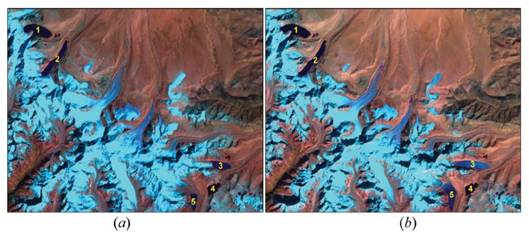
Lake dynamics mapping with Landsat TM. (a) Lake results on 12 October 1988. (b) Lake results on 7 November 2009