


Researchers Found the Observed Changes in Extreme Precipitation over the Tienshan Mountains and Associated Large-scale Climate Teleconnections
2022-02-21
Extreme precipitation (EP) often causes natural disasters such as floods, landslides and mudslides, posing an enormous threat to human society. Tienshan Mountain, Central Asia (TMCA) is not only the ecological barrier in the middle of the Silk Road Economic Belt, but also the main water source, which has profound impact on social and economic development of Central Asia and Northwest China.
Comprehensive understanding of the temporal-spatial variation characteristics of EP in this region and associated large-scale climate teleconnection mechanism is essential hence to comprehend the response of extreme events to global warming and finding better strategies to cope with water resources management.
A research team from Xinjiang Institute of Ecology and Geography, Chinese Academy of Sciences, reflected the changes of duration, intensity and frequency of EP in TMCA through 25 EP indices based on high-resolution and long-term grid precipitation data, and quantitatively evaluated the large-scale climate teleconnections, which is the most critical to EP based on geographic detector (GMD).
The research results show that the EP in TMCA develops towards wetting from 1951 to 2014, and shows obvious altitude dependence. Among them, changes in EP frequency shown to increase with event rareness. GMD found that SAM, AMO, NINOB, NSI, SF, AO and 30ZW are the most important factors affecting the change of EP. In general, strong zonal circulation at 500hPa, 1,000hPa potential height increases airflow from west to east. The westward extension of the western Pacific subtropical high and the increase in Mongolian anticyclone activity all bring sufficient exogenous water vapor from the North Atlantic and Indian Ocean to the TMCA.
The related results are published in “Journal of Hydrology” with the title “Observed changes in extreme precipitation over the Tienshan Mountains and associated large-scale climate teleconnections”.
Article link: https://authors.elsevier.com/a/1eRZD52cuXV34
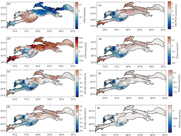
Fig. 1 (a) CDD, (b) CWD, (c) PRCPTOT, (d) R5mm, (e) Rx1day, (f) Rx5day, (g) R10mm and (h) R20mm show spatial trend changes in the TMCA during 1951-2014. (Note that the black dot in the figure indicates that the trend change at this point has passed the 95% confidence test.)
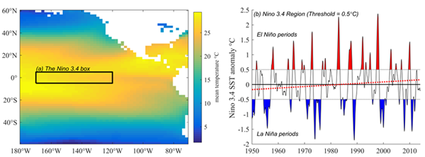
Fig. 2 (a) Nino 3.4 region on a map, and (b) the anomaly of Nino 3.4 index from 1951 to 2014. The thresholds of +/- 0.5℃ are used to identify El Ni?o and La Ni?a periods.