CMFD Data Stands Out in Repeat of High Asian Snowfalls
2023-10-30
The High Mountain Asia, as the third pole of the earth, is one of the more abundant snowfall regions on earth. Changes in snowfall not only affect the accumulation of glacial material in river headwater areas, but also greatly influence runoff processes and water resources, altering the composition of runoff components and complicating river hydrological processes. Therefore, accurate snowfall datasets are essential for natural process modeling, hydrometeorological analysis and prediction, and climate change monitoring. Reliable gridded snowfall datasets are essential for understanding snowfall in the region due to limited station observations in the region. However, the applicability of different precipitation datasets varies for different regions, so it is necessary to validate and evaluate their applicability and accuracy before further application.
To address the above issues, the research team of Chen Yaning from the State Key Laboratory of Desert and Oasis Ecology, Xinjiang Institute of Ecology and Geography, Chinese Academy of Sciences (CAS), comprehensively evaluated the applicability of six commonly used gridded snowfall products (ERA5, GLDAS, HAR, MSWX, NCEP, and CMFD) in the High Mountain Asia, and assessed and compared their ability to reproduce snowfall in different regions, at different altitudes, and at different time scales.
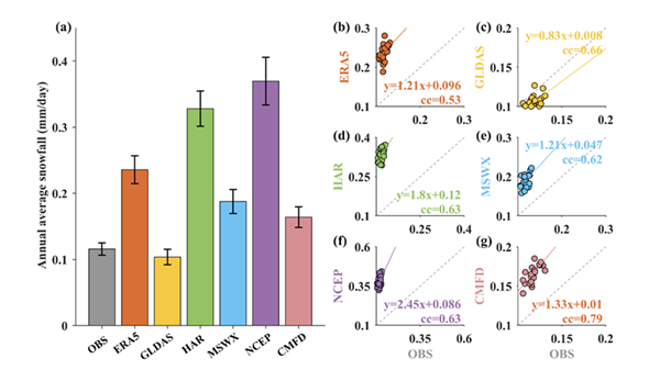
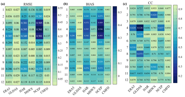
The results showed that (1) on the annual scale, CMFD exhibited the highest correlation (CC = 0.790) and the lowest BIAS (BIAS = 0.048), which was significantly better than the other datasets. On the monthly scale, the HAR, MSWX, and CMFD datasets showed high correlation and better capture of snowfall on the monthly scale. On the daily scale, MSWX exhibited the highest critical success index (CSI = 0.903) and the lowest false alarm rate (FAR = 0.076). (2) CMFD showed the highest agreement at different altitudes, indicating that it is less affected by altitude changes. Both MSWX and CMFD perform better in capturing snowfall at higher altitudes. (3) As the snowfall magnitude increases, the accuracy of each dataset exhibits a different degree of decrease. In terms of snowfall, all data sets perform better in capturing light snow, with the correlation between CMFD and HAR reaching 0.826 and 0.814, respectively. As the snowfall magnitude increases, the errors (BIAS and RMSE) begin to increase gradually, and only CMFD still maintains a high accuracy.
The related results were published in the Journal of Hydrology under the title of “Evaluation of Multiple Gridded Snowfall Datasets using Gauge Observations over High Mountain Asia”. The first author of the paper is Dr. Sun Fan of Xinjiang institute of ecology and geography, Prof. Yaning Chen and Associate Prof. Yupeng Li are the co-corresponding authors.This research was supported by National Key Research and Development Program, National Natural Science Foundation of China, and the Project of Tianshan Innovation Team in Xinjiang.
Article link: https://www.sciencedirect.com/science/article/pii/S002216942301288X?via%3Dihub#s0100

Figure 1 Evaluation of snowfall accuracy on the annual scale. (a) Comparison of gridded data with observations for multi-annual average snowfall; error bars represent standard deviations. Scatterplots of annual average snowfall between observations and the gridded datasets: (b) ERA5, (c) GLDAS, (d) HAR, (e) MSWX, (f) NCEP and (g) CMFD. Colored lines indicate the linear least squares results and dashed lines indicate the 1:1 ratio.

Figure 2 Statistical metrics for the evaluation of the six gridded snowfall products against observed snowfall in HMA at the monthly scale. (a) RMSE, (b) BIAS and (c) CC.
Contact:
LIU Jie
Xinjiang Institute of Ecology and Geography, Chinese Academy of Sciences
Phone: 0991-7885505
E-mail: liujie@ms.xjb.ac.cn
Web: http://english.egi.cas.cn/


