


Socio-hydrological Model Established for Simulating Farmers' Planting Behaviors
2024-05-30
In irrigation districts with water shortages, optimizing cropping patterns is crucial for improving water resources utilization efficiency and ensuring ecological sustainability. However, farmers’ planting behaviors and irrigation methods are influenced by different factors.
In a study published in Agricultural Water Management, researchers led by Prof. ZENG Fanjiang from the Xinjiang Institute of Ecology and Geography (XIEG) of the Chinese Academy of Sciences have examined the complex socio-hydrological feedbacks in the Qira oasis of Xinjiang, China.
Using an agent-based socio-hydrological model embedding Geographic Information Systems (ABSHM-GIS), researchers simulated the planting behavior of farmers, coupling government policies, agricultural irrigation, and crop growth processes.
First, researchers quantified the behavior indicators of farmers using data obtained from literature and questionnaire survey. Second, they established the ABSHM-GIS model within the Qira oasis region. Finally, they simulated farmers’ behaviors based on planned economic behavior theory, and water resource decision-making and allocation theory.
The simulation results show that with government subsidy, agricultural water consumption in 2023 can be reduced to 117 million cubic meters, a decrease of 20 million cubic meters compared to 2022. In addition, results indicate that for every 20 yuan increase in wheat subsidies, an average of 2 million cubic meters of water resources can be saved annually, which can then be allocated for ecological use.
Researchers also verified the model's accuracy by comparing the simulated planting structure with the actual planting structure. "The ABSHM-GIS model proposed in this study can be used in other similar regions," said XUE Jie, corresponding author of the study.
The study sheds light into the complex socio-hydrological system, and provides theoretical support for agricultural land-use planning and water resources management in arid regions.
Article link: https://doi.org/10.1016/j.agwat.2024.108845
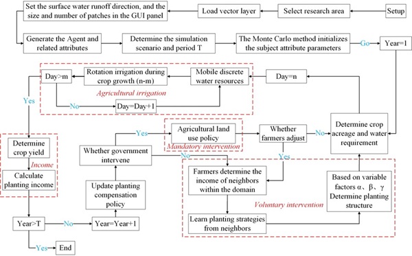
Flowchart of ABSHM-GIS model (Image by XIEG)
Contact
LONG Huaping
Xinjiang Institute of Ecology and Geography
E-mail: longhp@ms.xjb.ac.cn
Web: http://english.egi.cas.cn