



Study Improves Glacier Hydrological Simulation in the Tianshan Mountains by Incorporating Snow Redistribution
2026-07-08
A research team led by Prof. LI Zhi from the Xinjiang Institute of Ecology and Geography, Chinese Academy of Sciences (XIEG), has developed an improved glacier hydrological model to better quantify glacier accumulation, ablation, and runoff processes in the western Tianshan Mountains. The studywas published in Journal of Hydrology.
Glaciers and snowpack are critical freshwater sources for arid inland river basins in Central Asia. In the Tianshan Mountains, often referred to as the “water tower of Central Asia”, meltwater from glaciers and seasonal snow plays a vital role in sustaining downstream oases, agriculture, ecosystems, and transboundary water resources.
However, accurately simulating glacier mass balance and meltwater runoff remains challenging in high mountain regions because meteorological observations, snow water equivalent measurements, and glacier mass balance records are generally limited.
A key difficulty lies in the spatial redistribution of snow. In complex alpine terrain, snow does not simply accumulate and melt in situ. Instead, it can be redistributed downslope under the combined impacts of gravity, wind, snow density, and topographic conditions. Conventional semi-distributed hydrological models often neglect these processes, which may lead to unrealistic snow accumulation at high elevations and uncertainties in glacier accumulation, ablation, and spring runoff simulations.
To address this challenge, the research team developed an improved model, SWAT-Glacier-SRD (SWAT: Soil and Water Assessment Tool; SRD: snow redistribution module), by incorporating a snow redistribution module into the existing SWAT-Glacier framework. The new module redistributes snow from high-elevation areas to lower-elevation zones based on slope and snow density, thereby providing a more realistic representation of snow accumulation over glacierized terrain.
The model was applied to the Kumarik River Basin, a typical glacier-fed basin in the western Tianshan Mountains. The researchers used a multi-objective calibration strategy by integrating runoff, glacier area change, glacier mass balance, snow cover, and glacier melt contribution as constraints.
Compared with SWAT-Glacier, SWAT-Glacier-SRD showed better performance in simulating spring runoff and glacier-snow-related processes. For daily runoff simulation, the Kling-Gupta Efficiency reached 0.82 during the calibration period and ranged from 0.57 to 0.91 in the validation period. Biases in glacier mass balance and snow cover simulations were also reduced.
The study further quantified glacier accumulation and ablation in the basin from 1975 to 2019. Results showed that the mean glacier accumulation rate was 0.573 meters of water equivalent per year (m w.e. yr⁻¹), while the mean glacier ablation rate was 0.850 m w.e. yr⁻¹, resulting in an average glacier mass balance of −0.277 m w.e. yr⁻¹. Although glaciers in the basin continued to experience mass loss, the rate of loss has slowed in recent decades. Compared with 1975–1998, the mean glacier accumulation increased from 0.460 m w.e. to 0.697 m w.e. during 1999–2019, an increase of 51.7%, while ablation increased by only 8.0%. As a result, the glacier mass loss rate decreased from −0.359 m w.e. yr⁻¹ to −0.187 m w.e. yr⁻¹.
These findings indicate that glacier changes in the western Tianshan Mountains are not controlled solely by enhanced melting under climate warming. Changes in glacier accumulation also play an important role and should not be overlooked. The enhanced accumulation in recent decades may partly offset increased ablation and help explain the observed slowdown in glacier mass loss in the Kumarik River Basin.
The study provides a new modeling tool for quantifying glacier accumulation and ablation in data-scarce high mountain regions. By explicitly accounting for snow redistribution, the SWAT-Glacier-SRD improves the representation of glacier mass balance and meltwater runoff processes. The results are expected to support glacier change assessment, snowmelt runoff forecasting, and water resources management in arid regions of northwestern China and Central Asia.
Read the full article: https://doi.org/10.1016/j.jhydrol.2025.134266
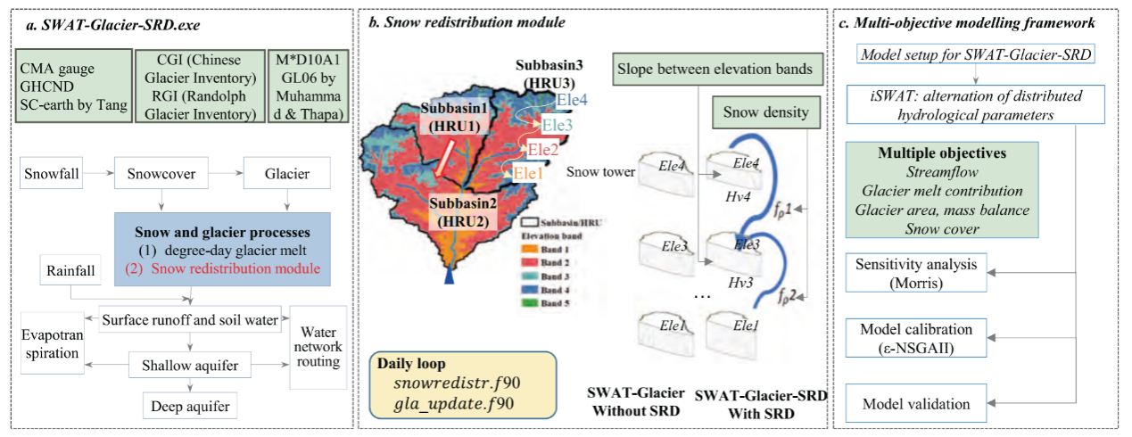
Fig. 1. Workflow of the model development and modelling framework. (Image by XIEG)
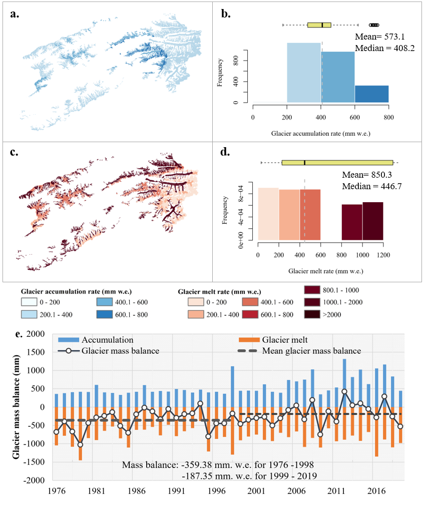
Fig. 2. Glacier accumulation and ablation in the Kumarik River Basin. (Image by XIEG)
Contact
FANG Gonghuan
Xinjiang Institute of Ecology and Geography
E-mail: fanggh@ms.xjb.ac.cn
Web: http://english.egi.cas.cn