



Study Reveals the Outbreak Mechanism of Extreme Wildfires in Arid Central Asia
2026-09-07
A research team on Ecosystem Monitoring and Change in Arid Regions of Central Asia from the Xinjiang Institute of Ecology and Geography, Chinese Academy of Sciences (XIEG), has systematically revealed the formation mechanism of extreme wildfires in arid Central Asia and resolved the scientific puzzle of why record‑breaking megafires can occur despite an overall decline in regional wildfire activity. The study was published in SCIENCE CHINA Earth Sciences on June 17, 2026.
Fire characteristics vary markedly across arid Central Asia owing to differences in vegetation types. The fire season for grasslands lasts up to nine months, while that for mountain forests spans approximately seven months. Wildfires in this region are predominantly distributed in north‑central Kazakhstan. Influenced by land‑use changes following the collapse of the Soviet Union, fire frequency in this area once rose in the early 21st century. Nevertheless, the overall annual burned area has shown a declining trend since 2000, with fire activities mostly concentrated between June and September.
Existing studies have largely focused on the spatiotemporal patterns, seasonal evolution, and meteorological drivers of long‑term fire regimes. Few have conducted in‑depth investigations into the synergistic triggering mechanisms of anomalous atmospheric circulation and fuel conditions for individual extreme wildfire events.
To address this gap, the team took this as their entry point to explore the key driving factors and potential mechanisms behind the 2002 extreme wildfire in Central Asia.
The results indicate that the total burned area across arid Central Asia exhibited a significant downward trend from 2001 to 2019. Even so, a historically unprecedented megafire broke out in central Kazakhstan between August and September 2002. The total burned area of this event reached 2.53 × 10⁷ hectares, more than three times the multi‑year average. Of the burned zones, 83.43 % lay in grassland areas of central Kazakhstan, and the burned area in these two months alone accounted for 75.12 % of the annual total.
To explain this anomalous event, the research team integrated multi‑source satellite wildfire datasets, vegetation observations, and large‑scale climate indices. Using cutting‑edge climate diagnostic methods, they fully reconstructed the “fire‑ignition chain” behind this extreme wildfire.
The study reveals that this megafire resulted from a Eurasian‑scale “climate relay”. Its core cause lies in an extreme phase reversal between wet and dry climatic conditions: a rainy spring fostered luxuriant vegetation, whereas dry and windy summer‑autumn conditions triggered widespread fire risk.
The first phase, in spring 2002, under the combined effect of the positive phase of the North Atlantic Oscillation and Scandinavian (SCAND) pattern signals, a stable Ω‑shaped blocking high continuously transported abundant water vapour from the North Atlantic into Central Asia, bringing the wettest spring precipitation in nearly two decades. This triggered rampant growth of local grassland vegetation, pushing vegetation indices to historically extreme values. Massive grass biomass withered under summer high temperatures, forming continuous, high‑load natural “fuel” for the subsequent massive fires.
The second phase, entering the high‑fire‑risk August‑September period, an anomalous Siberian cyclone over northern Central Asia acted like a “barrier”, forcibly altering water‑vapour transport pathways. This caused a sharp drop in precipitation across core Central Asia and triggered extensive severe drought. Sustained high temperatures, severe water shortage and near‑surface strong winds rapidly desiccated herbaceous plants. Fanned by persistent gales, the megafire ignited and spread rapidly on an unprecedented scale.
This study fills gaps in case‑based mechanistic research on Central Asian extreme wildfires and identifies the complete causal chain linking “large‑scale climatic signals – surface vegetation fuel loads – local meteorological drought”. It also puts forward practical new solutions for optimising regional fire‑risk early‑warning systems and formulating adaptive fire‑prevention governance strategies.
Read the full article: https://www.sciengine.com/SCES/doi/10.1007/s11430-025-1891-y
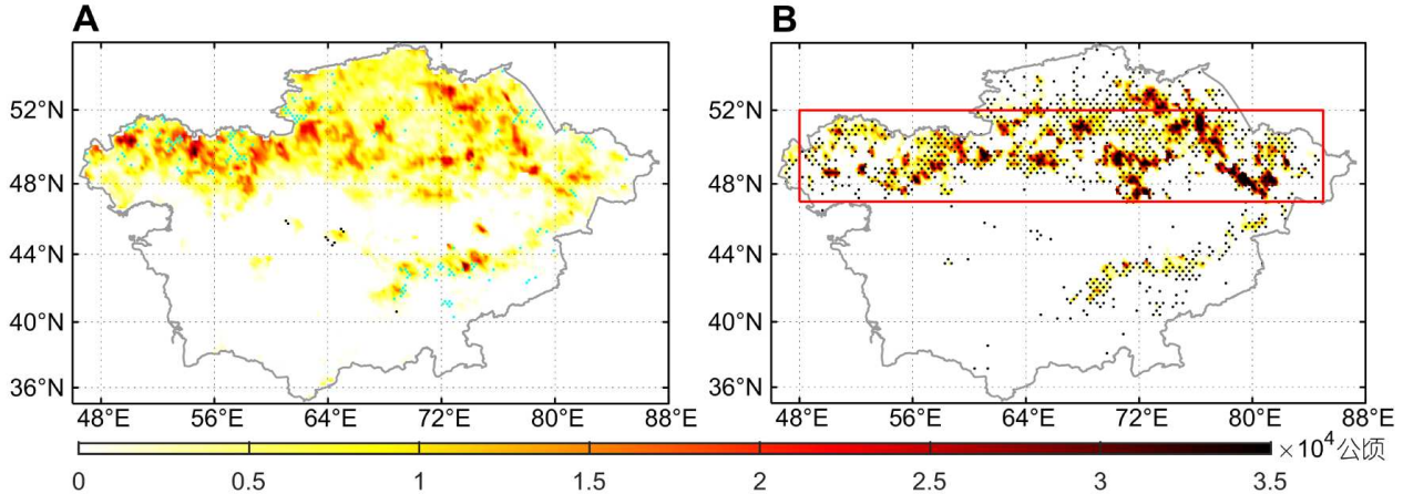
Figure 1 Spatial distribution of the mean annual burned area during 2001–2019 (A) and burned area in August–September 2002 (B) in Central Asia.
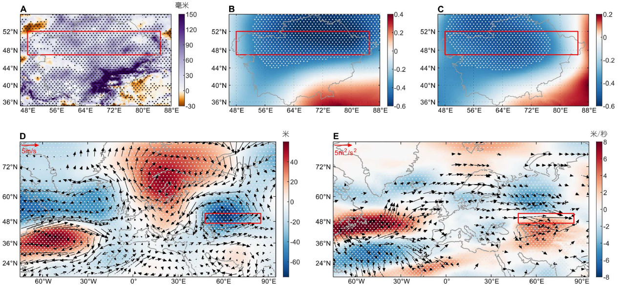
Figure 2 Composite analysis of atmospheric anomalies and teleconnection indices over Central Asia. (A) spatial distribution of spring precipitation anomaly in spring 2002; (B) correlation between 500 hPa geopotential height (Z500) anomaly and SCAND index in spring during 2001–2019; (C) correlation between Z500 anomaly and NAO index in spring during 2001–2019; (D) composite anomalies of UVZ500 in spring 2002; (E) anomalies of U500 and T-N wave activity flux in spring 2002. Dots indicate statistically significant correlations (p<0.1), and the red box denotes Central Asia.
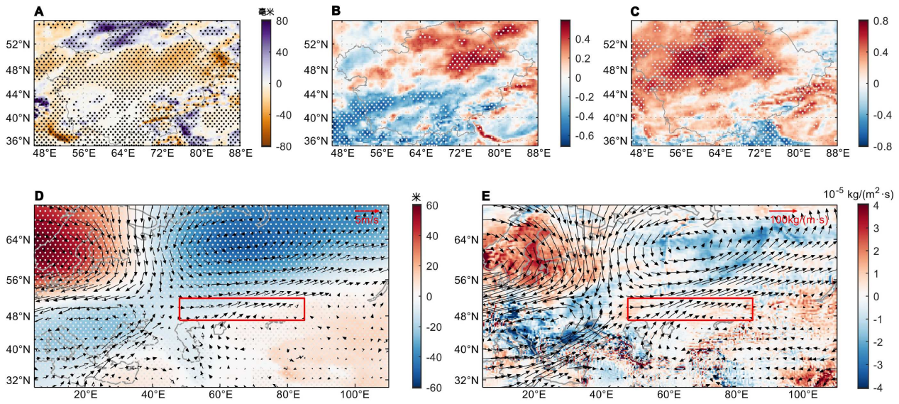
Figure 3 Spatial distributions of atmospheric and moisture-related anomalies: (A) precipitation anomalies in August–September 2002, (B) correlation between precipitation anomaly and the latitude of West Asian Jet core during 2001–2019, (C) correlation between precipitation anomaly and WAJI (Westerly Anomaly Jet Index) during 2001–2019, (D) Composite anomalies of UVZ850 in August–September of 2002, (E) Composite anomalies of vertically integrated divergence of moisture flux (VIDMF, shading) and vertically integrated moisture flux (VIMF, vector) in August–September 2002. Dots indicate statistically significant correlations (p<0.1), and the red box denotes Central Asia.
Contact
E-mail: zhdl@ms.xjb.ac.cn
Web: http://english.egi.cas.cn