



Ten Major Advances of the Third Comprehensive Scientific Expedition to Xinjiang
2026-10-15
Xinjiang is a core area of the Silk Road Economic Belt and an important ecological security barrier in northwestern China. It plays a vital role in safeguarding national ecological and food security, ensuring energy supplies, and keeping strategic channels smooth. The Third Comprehensive Scientific Expedition to Xinjiang was launched in 2021. The expedition received a total funding of 657 million yuan and was scheduled to run for five years. It comprised 30 projects, involved more than 6,400 person-trips in field investigations, and covered a total of 91,232 survey points.
With the balance between water and soil resources and water resource security as its central focus, the expedition conducted comprehensive regional investigations across five major zones, including water resources, the ecological environment, land and agriculture, biodiversity and biological resources, and mineral and energy resources.
The expedition systematically established a baseline of regional resources and ecological conditions, scientifically assessed resource and environmental carrying capacities and the potential for high-quality development, proposed pathways for regional green development, and continued to nurture scientific and technological talent committed to working in frontier regions.
Over the five years of scientific investigation, the expedition achieved ten major advances, providing robust scientific and technological support for implementing national strategies and safeguarding long-term social stability and security in Xinjiang.
Achievement 1: Marked Warming‑Humidification Trend Identified in Xinjiang, Increased Water Resources Create a Critical Window for Sustainable and High‑Quality Socio‑Economic Development
The expedition found that temperatures in Xinjiang have risenby 0.34° C every 10 years, approximately 1.7 times the global average and 1.13 times the national average. Precipitation has increased by 9.32 mm every 10 years, approximately 4.3 times the global average and 1.8 times the national average. The total area of glaciers lost has reached 2,167 square kilometers, representing an 8.4% reduction. In northern Xinjiang, the loss has reached 16%, indicating accelerated glacial melting. Meanwhile, available water resources have increased,with average annual river runoff rising by approximately 10 billion cubic meters and the area of lakes and wetlands expanding by 1/3. By around 2065, the water inflow of major rivers in southern Xinjiang is projected to continue increasing. Nevertheless, frequent natural disasters pose growing compound risks, with extreme heat and heavy precipitation events expected to become more common and exacerbate fluctuations in water resources.
The expedition’s findings have supported the development of controlled water conservancy pivot projects in the mountainous areas of Hotan and Aksu in the upper reaches of the Tarim River, helped guide the planning of Xinjiang’s water network, and informedan industrial development plan for usingApocynum venetum L. in sand control across 1 million mu (≈ 667 km²) in Yuli County, Bayingolin Mongol Autonomous Prefecture.
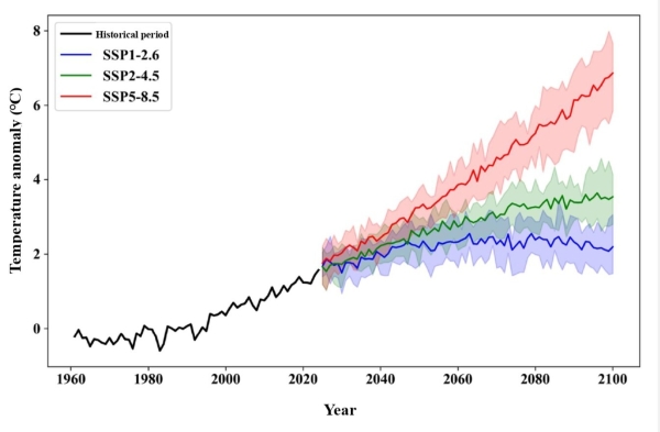
Figure 1: Annual average temperature variation trends in Xinjiang under different climate scenarios from 1961-2100. (Image by XIEG)
Achievement 2: Major Ecological Projects in Xinjiang Deliver Notable Positive Outcomes and Higher Carbon-Sink Potential, Underpinning Northwest China’s Ecological Security Barrier
The expedition found that vegetation in typical degraded basin ecosystems is showing signs of recovery, with vegetation coverage increasing by more than 30% and the regeneration capacity of desert forests significantly improving. The risk of wind and sand disasters in Xinjiang has declined, and Populus euphratica forests have shown clear signs of recovery.
Over the past 35 years, Xinjiang’s oasis area has expanded by a net 45,500 km², with artificial oases accounting for 98.7 % of the increase. This expansion is to continue, while the total ecosystem service value has risen by 17% and vegetation carbon sink capacity has increased by 20%. The expedition’s advances in forestry carbon sinks were included in the 100 Climate Actions from Cities in Asia and the Pacific and incorporated into the Major Engineering Planning for the Protection and Restoration of Important Ecosystems in Xinjiang. These achievements support the implementation of China’s national “Integrated Protection and Restoration Project of Mountains, Rivers, Forests, Farmlands, Lakes, Grasslands, and Deserts” in the Irtysh River and Aksu River basins.
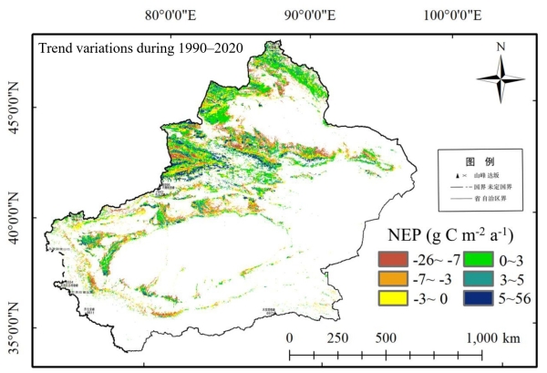
Figure 2: Changes in net ecosystem productivity of vegetation in Xinjiang. (Image by XIEG)
Achievement 3: Establishing Biodiversity Baselines and Identifying Novel Special Stress-Resistant Genes to Provide Germplasm Resources for Seed-Industry Innovation and Ecological Restoration
The expedition established a comprehensive baseline of Xinjiang’s biodiversity. Xinjiang is home to 4,828 species of wild higher plants, 1,259 more than those recorded in the Flora of Xinjiang before the expedition. It also has 810 vertebrate species, including 492 bird species, 153 mammal species, 60 amphibian and reptile species, and 105 fish species. The expedition discovered 33 new species and added 243 species newly recorded in China or Xinjiang. Across Central Asia, the expedition identified 9,643 vascular plant species, of which 3,409 are endemic to the region, representing an endemism rate of 35%. It also documented 982 vertebrate species and more than 20,000 invertebrate species.
For the first time, the exhibition digitized 1.32 million plant specimens from Central Asian, filling a data gap in the Global Biodiversity Information Facility (GBIF). It also demonstrated for the first time that Syntrichia caninervis, one of the most stress-resistant plants on Earth, can grow under simulated extreme Martian conditions. In addition, researchers screened 266 multi-stress-resistant plants and identified more than 300 excellent stress-resistant genes for drought resistance, salt tolerance, and disease resistance. They also developed transgenic cotton varieties that reduced water consumption by 25-40% and conferred resistance to verticillium wilt.
The expedition’s advances in ungulate conservation in Kalamaili helped integrate the reserve into the national park system. Its work on conserving the Tianshan wild fruit forest was incorporated into the legislation of Ili Prefecture, while the Ili-Turpan Botanical Garden was included in the State Council’s Layout Plan for the National Botanical Garden System.
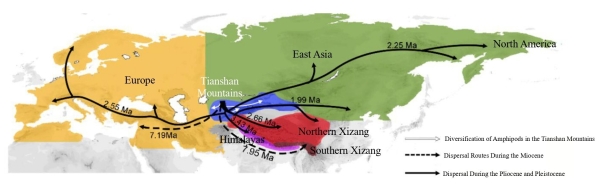
Figure 3: Amphipod dispersal routes. (Image by XIEG)
Achievement 4: Confirming Abundant Reserve Cultivated-Land Resources and Distinct Advantages of Special-Feature Agriculture to Support the Development of a National Key Supply Base for High-Quality Agricultural and Livestock Products
The expedition produced the first 1:250,000-scale map of vegetation formation types across Xinjiang grasslands, covering a total area of 786 million mu (≈ 524, 300 km²). Medium- and high-quality grasslands with low productivity account for 78% of the total, indicating that a dynamic balance between grassland resources and livestock demand has largely been achieved. Xinjiang has 106 million mu (≈ 70,700 km²) of cultivated land, of which nearly 70 million mu (≈ 46,690 km²) is under drip irrigation under film-mulched drip irrigation. Over the past 30 years, this irrigation method has not caused salt accumulation in the cotton root zone, making it the optimal water-saving solution for Xinjiang’s agriculture.
Xinjiang has more than 100,000 mu (≈ 66.7 km²) of contiguous saline-alkali wasteland and grassland, while its total saline-alkali land area reaches 116 million mu (≈ 77,370 km²), making it a potential reserve for cultivated land in China. The region is also rich in halophytic plant resources, with 315 species accounting for 56.7% of the national total. These plants can be planted, improved, and utilized in severely saline-alkali areas to develop characteristic halophytic agriculture.
In addition, a selenium-rich belt stretching 1,000 kilometers and covering 22 million mu (≈ 14, 670 km²) was discovered along the northern margin of the Tarim Basin, offering new opportunities for the development of characteristic agriculture.
Related advances included the release of the ANSO scientific report Eurasian Grassland Change and Sustainable Development at the UNCCD COP17. The report’s findings were incorporated into saline-alkali land improvement plans for the Xinjiang Uygur Autonomous Region and the Xinjiang Production and Construction Corps (XPCC), with implementation covering 135,000 mu (≈ 90.05 km²) across Xinjiang. In addition, the “precise water and fertilizer diagnosis and irrigation technology system in irrigation areas” was included in the Ministry of Water Resources’ 2024 promotional list of mature and applicable water conservancy science and technology advances.
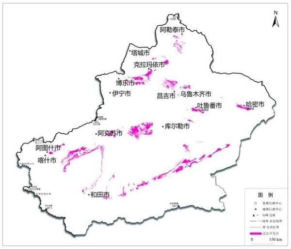
Figure 4: Distribution of suitable areas for the development of saline-alkali wasteland (grassland) in Xinjiang. (Image by XIEG)
Achievement 5: Accretionary-Orogenic Metallogenic Theory and Intelligent Prospecting Technologies Developed, Robustly Underpinning Xinjiang’s New-Round Strategic Initiative for Mineral-Exploration Breakthroughs
The expedition reconstructed the tectonic framework of the Central Asian Orogenic Belt and developed a terrane collage and multi-directional convergence compound accretionary orogeny model. It clarified the spatio-temporal distribution of metallogenic systems and established the continental accretion-metallogeny theory. The expedition also revealed that tectonic differences among different metallogenic belts are the fundamental reason why “major mineral deposits rarely cross national borders,” providing new direction for mineral exploration in Xinjiang. This theory has supported major breakthroughs in mineral prospecting, including the discovery of the Dahongliutan super-large lithium deposit, the Huoshaoyun super-large lead-zinc deposit, the Eastern Tianshan vanadium-titanium magnetite belt, and the Lup Nur West potassium salt.
The expedition also developed hyperspectral technologies for identifying ore bodies and elements, facilitating the discovery of new orebody deposits. Suggestions concerning “Xinjiang vanadium-titanium magnetite” resources supported the development of a vanadium-titanium magnetite exploration and development base with a target capacity of 100 million tons. In addition, a plan was proposed to establish a green industrial cluster covering the entire value chain, from exploration and development to deep processing and utilization. A mineral resource base with a target capacity of 10 million tons was established in Hotan and other areas, and the first batch of zinc ingots from Huoshaoyun officially rolled off the production line.
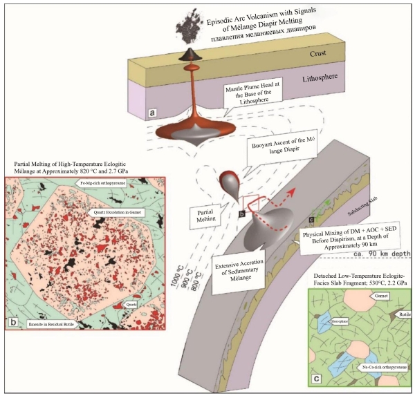
Figure 5: Coupling law of partial melting of deeply subducted slabs and porphyry mineralization in the Western Tianshan. (Image by XIEG)
Achievement 6: Favorable Resource Endowments of Oil-Rich Coal Verified in the Turpan-Hami Basin, Driving Reserve and Output Growth in Support of Building a National Modern Coal-Chemical Base
The expedition found that oil-rich coal resources in the Turpan-Hami Basin are highly concentrated and of excellent quality. Proven reserves total 64 billion tons in Hami and 13.5 billion tons in Turpan, with an average tar yield of 12%. This rare coal type, which combines the properties of coal, oil, and natural gas, has significant potential for development and utilization. Every 100 million tons of oil-rich coal can yield the equivalent of 34.5 million tons of oil and gas, creating opportunities to establish a strategic mineral resource exploration and development base.
Recommendations on the efficient and comprehensive utilization of oil-rich coal were adopted by six ministries and commissions, including the National Development and Reform Commission, the Ministry of Industry and Information Technology, the Ministry of Natural Resources, and the National Energy Administration. The proposal to “promote the development of strategic coal-to-oil and coal-to-gas bases in Hami and other parts of Xinjiang” was incorporated into the National Development and Reform Commission’s 15th Five-Year Plan for Petroleum and Natural Gas Development. In addition, the proposal to “construct the Hami National Comprehensive Energy and Industrialization Demonstration Zone” was incorporated into the 2024 national economic and social development plan of the autonomous region.
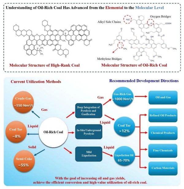
Figure 6: Efficient and comprehensive utilization of oil-rich coal. (Image by XIEG)
Achievement 7: Multi-Scale Effects of Aeolian-Sand Environments Uncovered and a New All-Factor Sand-Control Model Established, Delivering Scientific and Technological Support for the Full-Scale Desert-Edge Sand-Blocking Campaign
The expedition clarified the formation and evolution of the Taklimakan Desert and identified the pathways of aeolian sand transport. For the first time, it dated the formation of the desert’s modern landscape to approximately 300,000 years ago. It also identified the vertical dust diffusion zone at altitudes of 8,000–12,000 meters and traced the dust transport pathway characterized by “moving west and flooding east, crossing mountains and heading south.” It also delineated the high-risk degraded areas and protection gaps around the Taklimakan Desert.
Building on these findings, the expedition developed a comprehensive sand control model incorporating all relevant factors and proposed a desert-edge protection strategy centered on “wind prevention—sand blocking—dust control.” The strategy was adopted by the National Forestry and Grassland Administration. Expedition members were subsequently appointed to lead the national expert group for the desert-edge protection campaign and the expert group for the Xinjiang Uygur Autonomous Region’s desert-boundary protection project.
These advances were incorporated into the “Desertification Prevention and Control Plan of the Xinjiang Uygur Autonomous Region (2021-2030)” and the “Overall Scheme for the Desert Edge Blocking Battle in Taklimakan, Xinjiang.” They supported the successful completion of a 3,046‑km desert‑edge enclosure project around the Taklamakan Desert. The expedition’s work also contributed to the “Taklimakan Desert Border-Locking Project” being recognized as one of the “2025 Global Top Ten Engineering Advances” and was highlighted in the 2025 government work report of the Xinjiang Uygur Autonomous Region.
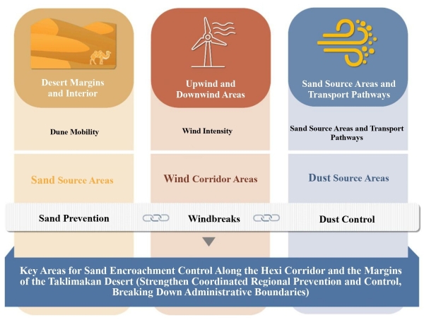
Figure 7: Overall concepts of the desert edge blocking battle scheme. (Image by XIEG)
Achievement 8: Cross-Border Ecosystem Conservation Proposals Support Building China’s Geoecological Security Barrier through Science and Technology
The expedition elucidated changes in ecosystem characteristics across national borders. In the Ili River basin, habitat quality remained largely stable within China and generally improved in neighboring countries. Similarly, in the Irtysh River basin, habitat quality within China remained largely stable, while the ecological service functions of the taiga forests on the southern slopes of the Altai Mountains improved overall and habitat quality in neighboring countries continued to improve. Overall, the findings indicated that water resource utilization in the upper reaches of transboundary rivers had not adversely affected water resources, ecosystems, or biodiversity downstream.
The expedition proposed a transboundary biodiversity conservation plan and developed a multinational framework for quantitatively assessing countries’ conservation responsibilities. These advances helped establish the “Beijing Consensus” of the China-Russia-Kazakhstan-Mongolia Altai Mountains Cross-Border Protection Alliance. The initiative was incorporated into the State Council’s General Plan for Establishing China (Xinjiang) Pilot Free Trade Zone and the “15th Five-Year Plan for Cultural and Tourism Development of the Xinjiang Uygur Autonomous Region.” These achievements provide scientific support for the four countries to jointly strengthen the regional ecological security barrier and plan the development of cross-border national parks.
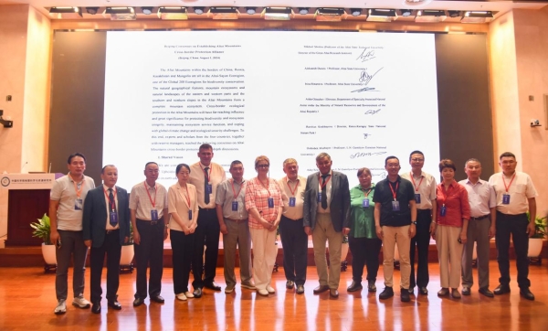
Figure 8: Organized and released the “Beijing Consensus” of the Altai Mountain Cross-Border Protection Alliance. (Image by XIEG)
Achievement 9: The “Space-Air- Ground” Integrated Observation and Scientific-Data Management System Completed, Underpinning Enhanced Intelligent Decision-Making Capabilities in Xinjiang
The expedition established a comprehensive, networked ecological monitoring system across Xinjiang by integrating 42 existing ground stations and adding eight comprehensive ecological observation stations. This enabled continuous, long-term monitoring of 12 types of land-surface parameters, shifting from “static descriptions” to “dynamic assessment and analysis.” The expedition also standardized scientific expedition data and historical records, consolidating approximately 180 TB of data. It released more than 2,800 datasets for public access and facilitated the sharing of 293 TB of data. In addition, it secured approval for Xinjiang’s first scientific data center, “the Xinjiang Uygur Autonomous Region Ecological and Resources Scientific Data Center.”
The expedition developed an intelligent joint dispatch system for seepage and rotational irrigation along the Tarim River. The system was successfully applied to ecological water conveyance projects and increased the efficiency of ecological water use by more than 10%. Moreover, the expedition integrated an intelligent safety monitoring system for major reservoirs in Xinjiang, enabling high-precision monitoring of dam deformation trends. The system was adopted by the regional water resources department. Furthermore, the expedition developed an avalanche monitoring and early warning system that was successfully deployed in Xinjiang and subsequently promoted in neighboring countries, earning its developers Tajikistan’s National Medal.
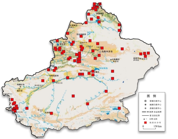
Figure 9: Construction status of observation stations. (Image by XIEG)
Achievement 10: Expedition Outcomes Disseminated to Belt-and-Road Partner Countries, Facilitating Chinese Solutions to Go Global
The expedition compiled the Atlas of Land Cover in Five Central Asian Countries, which was released at the “Belt and Road” Young Scientist Forum. It also compiled the Atlas of Glaciers in Tajikistan, which was unveiled at the “High-Level International Conference on Glacier’ Preservation.” In addition, it established demonstration zones for ecological shelterbelts in Kazakhstan’s capital region and saline-alkali land management in Uzbekistan’s Aral Sea region.
These achievements were included in the List of Deliverables of the Third Belt and Road Forum for International Cooperation in 2023 and selected for the first batch of initiatives under the UN “Science Decade” in 2025. Furthermore, the expedition established the “Biodiversity Conservation Alliance for Arid Lands” and the “China-Tajikistan Belt and Road Joint Laboratory on Biodiversity Conservation and Sustainable Use”. These advances have benefited countries participating in the Belt and Road Initiative, helping extend Chinese solutions to the international community.
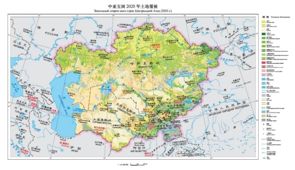
Figure 10: Land cover map of the five Central Asian countries. (Image by XIEG)
The scientific expedition summarized and formed its major discoveries and advances into the framework of “Three Gains and Three Developments”: increased water—overall improvement of water resource conditions; increased greenness—continuous ecosystem improvement; increased momentum—accelerated transformation of resource advantages; new knowledge—discovery of new regularities and understanding of new baselines; new policies—application of new technologies to form new models; and new platforms—building new carriers and strengthening new support.
The Third Comprehensive Scientific Expedition to Xinjiang has provided a solid scientific and technological foundation and a comprehensive “base map” to guide Xinjiang’s high-quality development. By translating this scientific foundation into tangible outcomes, the expedition has contributed to safeguarding long-term social stability and security in Xinjiang and improving livelihoods to help build a stronger Xinjiang.
Contact
HUANG Zhuanli
Xinjiang Institute of Ecology and Geography
E-mail: zlhuang@ms.xjb.ac.cn
Web: http://english.egi.cas.cn